Tobias Knerr

de en

Open Source projects

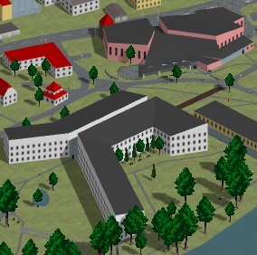
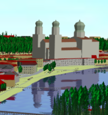
OSM2World creates 3D models from OpenStreetMap data.

This open source renderer displays OSM data with OpenGL or exports them to formats such as OBJ or glTF. The Java source code is available on GitHub.

MapSplit divides a large OSM dataset into many smaller tiles.

I've contributed various features and performance optimizations which allow the tool to process continent-sized PBF extracts.

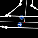
GraphView helps mappers spot errors in road network data by displaying a routing graph preview.

I created the first version of this plugin for the Java OpenStreetMap editor as a part of my Bachelor thesis and have since added more features to it.

Former Open Source projects

The Isometric Slippy Map shows OpenStreetMap in 2.5D.

This map based on server-side 3D rendering and OpenLayers was the first attempt to present OSM2World on the web and triggered the first major boost to 3D mapping with S3DB tags. It is being replaced with a more modern solution based on WebGL.

The TTT software tables were a catalogue of the OpenStreetMap software ecosystem.

User-generated content is parsed by a MediaWiki bot written in Scala. A number of tables in the OpenStreetMap wiki provide different views of available programs, filtered by purpose, audience or platform.

ComillaBot was used to fix minor typographical errors in Wikipedia articles.

This semi-automated tool detects common issues ranging from incorrect quotation marks to ISBN formatting errors and proposes fixes. To implement this functionality, I used, and contributed improvements to, the JavaWikiBotFramework.

Research projects

KI-DT (2020–2023)

As part of the KI-DT research project, we're providing tools for storing and organizing training data for autonomous vehicles.

@CITY (2018–2022)

As part of the @CITY project, which aimed to advance automated driving in urban areas, we worked on processing digital maps in OpenDrive and Protobuf data formats with centimetre precision and displaying them with tools such as QGIS, Leaflet and Cesium.

Ko-HAF (2015–2018)

To enable cooperative highly automated driving as part of project Ko-HAF, we implemented a tile-based approach to distribute continually updated, highly accurate road maps through LTE mobile connections, as well as an MQTT solution for exchanging information on current events between vehicles.

Ko-PER (2011)

At the University of Passau FORWISS institute, I implemented real-time 3D rendering of map data in a simulation framework using C++ and OpenGL.

Verdikt (2007–2008)

As a research assistant at the Chair of Information Management of the University of Passau, I contributed to Verdikt – a system for document validation.